



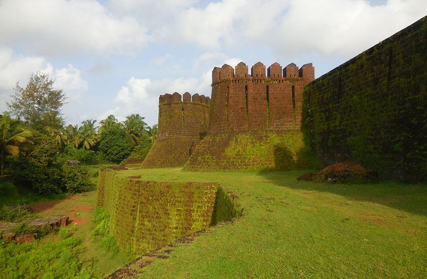
The imposing Mirjan Fort is hauntingly beautiful during the monsoon
Mystery fort in the rain
Susheela Nair
In the midst of the monsoon, where do you go for a holiday? While most tourists trudge to sparkling waterfalls scattered all over Karnataka, we headed to the off-beat destination of Mirjan Fort in Uttara Kannada to savour the magic of the monsoon. We found the imposing fort breathtakingly beautiful, covered with a carpet of green moss. Huge bastions along with watchtowers loomed into view as we reached the fort.
On entering the portals of the historic battlement up the broad laterite stone steps, a haunting tranquility greeted us and we felt as though we had the fort to ourselves. Sans any hawkers, visitors or busloads of day-trippers to hassle us, we could savour the beauty of the fort in blissful silence and absolute solitude.
Located amidst the idyllic setting of the bank of the Aghanashini river, the ruins of Mirjan Fort in Uttara Kannada district were truly splendid to behold, their earthy colour interspersed with vibrant green. The monsoon had transformed this historical marvel into a lush paradise. We wandered through misty pathways, explored its iconic ramparts, and soaked in the breathtaking views of the Aghanashini, swaying coconut trees, lush paddy fields, greenish groves and the Western Ghats in the background. Perched on a little promontory against the background of verdant hillocks, the red laterite structure stands regally even in its ruinous state.

As we clambered up the steps leading to a watchtower, it conjured up visions of intriguing battles fought for the supremacy of trade. It must have once resounded with the boom of cannons as battles raged for control of the fort and its surroundings. We got a bird’s eye view of the landscape from the watchtower. In its heydays, the fort was surrounded by a protective circular moat, believed to have been infested with crocodiles to guard against any attack. The waterway enabled transportation of merchandise to the nearest harbour. Sadly, the moat is not visible, now hidden under overgrown bushes. There are also indications of a drawbridge that once existed.
Sprawled over ten acres, the strategic citadel is an architectural marvel with its bastions. As we rambled, we could still see the large entrance, walls, flag-pole, watchtowers, remains of an assembly hall, a darshan hall, prayer halls, a marketplace, and idols of gods under a massive solitary tree. In addition to the main entrance, the fort has three subsidiary entrances, secret passageways and canals, providing a royal reminder of our vibrant history. It has witnessed several battles yet endured the test of time.
Mysterious and secret underground tunnels and routes to escape invasions added to its intrigue. The double-walled citadel boasts a unique blend of Islamic and Deccan architectural styles with high walls and bastions. We could imagine the level of security provided by the inner walls that could clearly resist invasion by enemies.
We were overwhelmed by the architectural skills that the builders possessed at a time when technology was unheard of. This time-tested structure, built using locally available laterite stones, has weathered the vagaries of nature and time and stands strong even today. With four entrances and as many freshwater wells, Mirjan was a city in itself. Capable of withstanding long sieges and located at a vantage point, controlling the harbour, Mirjan Fort was strategic for anyone hoping to rule the region.
The deep wells, secret doors, tunnels, kitchens, watchtowers, and other ruins made us ponder the former significance of the place. The water storage system and large wells were connected to canals and tell us about the source of water inside the fort. When we learnt of the routes linking the fort’s several wells to the fort exterior and the canal surrounding the fort, we presumed the waterway must have been used to ferry cargo, making the area a vibrant trading centre. After many restorations, the Archaeological Survey of India has declared the fort a protected monument under its purview.

The place resonates with history and abounds in several scattered ruins of imposing historical monuments that transport one to the glorious past, to a time when Mirjan was a busy outpost in the Konkan coastal belt. The fort’s strategic location near the Aghanashini river provided access to the Arabian Sea, making it a vital trading and defence hub. It served as an export base for an assortment of spices like pepper, nutmeg, and also betelnut produced in the flourishing Vijayanagara Empire. Pepper, a much-sought after spice in those days, wound its way to the cities of Europe.
However, the origins of the fort can be traced to a myriad of versions. This fort with Deccan and medieval influences has been home to many rulers over the centuries. While some sources date the fort’s construction to AD 1200 during the period of the Nawayath Sultanate, one of the first historical records attributes its reconstruction to Chenna Bhairadevi, the illustrious Queen of Gerosoppa. As she controlled the pepper trade through this fort, she was known by the Portuguese as ‘Raina-Da-Pimenta’, which meant Pepper Queen in Portuguese. The queen held sovereignty over the region for more than half a century, and showed statesmanship and bravery, but ultimately died a prisoner.
Fact File
Getting there: It is 1 km from NH-17, Kumta (11 km) and Gokarna (22 km) in Uttara Kannada region of Karnataka.
Where to stay: Options for accommodation are meagre in Mirjan but there are places to stay in nearby Gokarna and Kumta.
Comments
Currently there are no Comments. Be first to write a comment!